Recently, MFI’s brother Jim texted her and asked if she’d like their father’s journal. She replied “yes,” not really knowing what this journal might be. What we received was a 4″ x 7″ leather bound 1936 Year Book printed by The Milwaukee Electrotype Co. out of Marquette, WI. Inside the front and back covers were single-page monthly calendar for 1936 and 1937, respectively. The Year Book was primarily a journal containing blank pages for each day of the year, but also ended with 16 pages covering what for that time was thought to be helpful for record keeping and general information, possibly. Those pages included: monthly cash accounting with an annual summary, addresses, insurance records, detailed postal rates and information, populations of principal U. S. cities for 1920 and 1930, common weights and measures with metric equivalents, tables for calculating interest on investments, and sound recommendations in case of accidents. I found these data very interesting in several regards. First, the postage for local letter delivery was 2 cents; 1 cent for a postcard. Second, the 1930 population of Seattle, WA was 365,583 as compared to 755,078 in 2023. The relevance of my highlighting Seattle will become apparent later in the blog

Bill had used the Year Book to record one-day summaries of a 40-day road trip he and two friends (David and Abraham, nick-named Abie) took the summer after graduating from high school. Bill was 18 years old at the time of the trip. His entries described the cities/towns they passed through and those where they camped or detoured for sightseeing. Using this information, I mapped their trip with our RV Trip Wizard application and closely estimated they travelled 6,138 miles between Williams Bay, WI and Los Angeles, CA where the journal and trip ended.

While it was impossible to know exactly where they stopped for provisions, gas, meals, repairs,or sightseeing; I can confirm based on his journal entries they made at least 60 stops. Bill titled each journal page, so using his titles, I share in this blog the highlights from his entries. Because he was understandably short on room for including many details, I researched specific sites they saw and provide readers with supplemental details and photographs.

This is quite a long read, so sit back and enjoy my attempt to relive their roadtrip adventures.
Good Wis[consin] Scenery; Monday, June 22, 1936 – They departed Williams Bay, WI early; drove 355 miles; and camped that night next to a pig sty in Algona, IA. He made the first of many comments about the bad road conditions.
Prairie Day – Tumbleweed; Tuesday, June 23, 1936 – The trio drove 25 miles before experiencing a flat and mangled tire. Fortunately, it was still under warranty and was repaired in Mitchell, SD. Unfortunately, Bill took over driving duties and proceeded to roll the trailer. Fortunately, there wasn’t much damage. Unfortunately as a result of the delay, it took them 12 hours to travel 291 miles for their overnight in Kimball, SD. Bill never mentioned what type of vehicle they were driving, or the make and size of the trailer. He did write that the trailer was only used for hauling their gear and provisions.
Badlands Day; Wednesday, June 24, 1936 – They travelled another 291 miles to Rapid City, SD; but this time it took less than 9 hours with no flats. The morning scenery was described as windy, fenceless, and rolling prairies populated with jack rabbits and tumbleweeds. Next, they drove across the Badlands, which Bill described as jagged and barren and hot (120 F). Took their first shower at the evening’s camp in Baken Park near Rapid City, ND. Here are two of our Badlands pictures from Aug 2022 to illustrate what they likely saw.


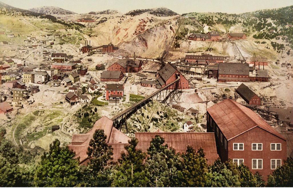
Black Hills (Mts. Abie says); Thursday, June 25, 1936 – The boys slept late, arose at 0630, unhitched the trailer, drove through the historic gold rush town of Deadwood, SD, and “took in” the world’s largest (and eventually deepest at 8,000′) gold mine in Lead, SD. The mine was called The Homestake. In the early 1900’s, gold ore was being mined no deeper than 1,550 feet; however, at the time of their visit, the new (1934) Ross mineshaft allowed mining down to 3,500 feet. Bill gave it one of his highest recorded accolades, writing “…very interesting.”
They stopped and toured Wonderland Cave in Nemo, SD along their return drive to camp. Bill wrote, “…interesting – my first cave trip.” I found these pictures online, although there’s no telling whether they saw these views during the tour.


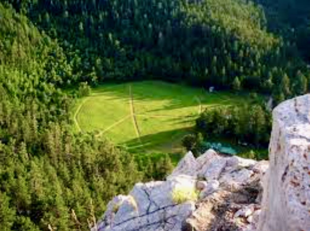
After picking up the trailer back in Rapid City, they ate lunch while the car was being fixed (no explanation offered). They drove about 17 miles to see the “Stratisphere [sic] Bowl” outside of Rockville, SD. Bill wrote only “…saw all – very good.” The Stratosphere Bowl was a natural, protected land depression from which record-breaking stratospheric balloon flights were launched during the 1930’s. Clearly, our trekkers were somehow aware of what had occurred there to know to stop. In 1935, Explorer II launched from there and reached an altitude of 72,395′, a record which stood for 21 years. Today, Stratosphere Bowl is a popuar hiking spot and hosts an annual hot air balloon launch in September to celebrate the historic launches, which were America’s precursor to the space age. Based on having driven 160 miles on this day, they probably camped in the vicinity of Keystone, SD.
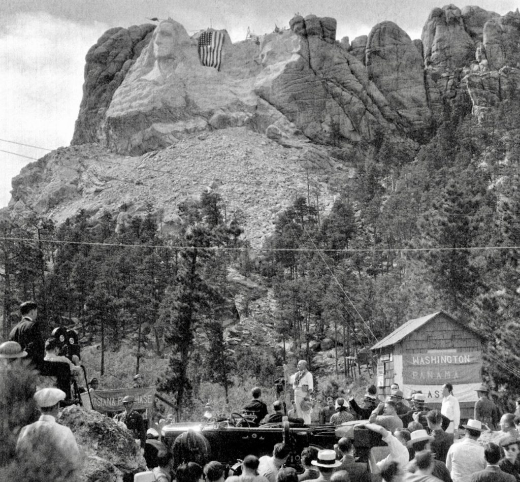
Still Black Hills; Friday, June 26, 1936 – Two got up at 0430 after it had been raining for several hours. David slept through it in a wet sleeping bag. They headed off at 0615 to see Mount Rushmore but got so lost, that it took them 3 hours to travel 34 miles. No impressions were recorded, so unclear what they saw. But a month after their visit, President Roosevelt (FDR) attended a dedication for the completion of Washington and Jefferson. In Aug 2022, we thoroughly enjoyed our visit to Rushmore where I took many pictures.

Just 4 miles past Rushmore, the group saw Harney Peak, the highest point east of the Rockies at 7,229 feet but again recorded no impressions. The Peak was named after U.S. Army General William S. Harney who savagely killed Lakota Sioux warriors, women, and children in the Battle of Blue Creek, a punitive retaliation for Sioux raids in Sep 1885. In Aug 2016 after 94 years, the Lakota were finally successful in having the name officially changed to Black Elk Peak. Black Elk was a revered medicine man known for his wisdom. Because of its sprawling view of the surrounding National Forest, a permanent fire watch tower was constructed atop the mountain in 1938, replacing the 16′ x 16′ wooden tower Bill and his friends would have likely seen.

Driving over the Rockies, they “…hit desert” in the late morning. Our current atlas shows no desert in eastern Wyoming, but rather describes the terrain as higher-elevation grasslands. They stopped in Casper, WY at 5:30 pm because both a tire and the radio required repair. This took so long, they camped in Casper for the night with Casper Mountain (elevation 8,130 feet) visible to the south rising 3,000 feet higher than their campsite. Bill ended his entry with “…our beds are full of red ants. – Oh for the life of a sailor/280 miles.”

After lunch, they drove 100 miles of mountain roads south to Jenny Lake in the Grand Teton National Park. Along the way, they “…saw several fumroles [sic] and hot springs.”


Bill described their campsite on Jenny Lake (elevation 6,781′) as “…wonderful…” with six peaks as high as 13,776′ (Grand Teton) only 3 miles west as the crow flies.
The Grand Tetons!! Monday, June 29, 1936 – The men slept until 8 am and took a “…slow breakfast.” Later in the morning, Bill and David mounted horses and rode 7 miles around the lake. Bill wrote “I didn’t get F. F. from my first ride after such a length of time.” My research failed to disclose what he meant by F.F. The rest of the day, the three enjoyed the landscape, lounged around their campfire, and retired early.
We climb the Teewinot; Tuesday, June 30, 1936 – In an example of Bill’s sense of humor, as presumed by MFI, he wrote this entry, which we believe he meant to be read with a country drawl. “Ye Gods! 5:30 rising time again…we are all anxious to get climbing mts. and it was terribly cold in these here now woods, anyhow.” He then wrote “Wal -” before continuing, and we decided that was “well,” but again spoken with the same country drawl. By noon, they climbed to the 10,500 feet elevation of Teewinot (12,326 feet summit) and “…dined luxuriously…” on the shores of Lake Solitude. Unfortunately, I couldn’t reconcile these recorded data. While climbing to 10,500 feet was easily achievable, Lake Solitude was 1.5 miles (as the crow flies) west northwest of, not on, Teewinot Mountain; and the lake’s elevation was only 9,055 feet. Hmmmm!


I was beginning to think the elevation and cool mountain air may be fogging Bill’s mind. He began sneaking a little french into this day’s entry and comically described lunch as being “…below the pow snad cleaks* of the Grand Teton.” Who doesn’t appreciate a clever spoonerism? After returning from their hike at 4 pm, “we…went for a swim in a ‘tres froid‘** Lake – Jenny over 400 feet deep.” He finished his entry with “…the nights are perfect – almost full moon – cool mnt. air, mts., deep clear lake & camp pas mal.”***
Asterisked translations: *snow clad peaks, **very cold, ***not bad
On to Yellowstone & Old Faithful; Wednesday, July 1, 1936 – They awoke at “6:30,” were greeted by near freezing temperatures, “…bid adieu to the Grand Tetons which were certainly Grand,” and drove 100 miles north to Mammouth Hot Springs to pick up mail for the first time. After noon, they drove slowly back to see Old Faithful, ate, watched the Geyser erupt 3 times, and “…barged into the swanky Hotel dirty and dressed in rags.” The swanky hotel was the Old Faithful Inn, one of world’s largest log style structures, opened in June 1904, and changed little in 122 years except for some wing expansions. They attended a dance that evening, which Bill described as not bad, and all were in bed by 11:00 pm. These pictures illustrate the rustic look of the hotel.


Somewhere in Montana; Thursday, July 2, 1936 – They drove 297 miles through Montana valleys and camped beside a little mountain stream located about 15 miles south of Missoula, MT. Claimed road conditions were the best so far. Stopped for groceries etc. in Butte, MT. At bedtime, Bill wrote “It looks like rain. Damn the Bugs!!“
More Montana; Friday, July 3, 1936 – They continued north to Flathead Lake, and although they didn’t identify exactly where they stopped, Bill jotted down “we saw a probable Prin. [Principia] student – Don Skaric & had lunch with his Aunt and Uncle.” There was no further explanation of who these people were or why they visited them. They drove further north into Glacier National Park and camped at Avalanche Park (called Avalanche Campground today) “…in a valley infested with tourists. At last!! – no bugs!”
MFI and I drove past the west side of Flatead Lake in May 2024, and I photographed its beauty.


Glacier Park and Tourists. What a Moon!! Saturday, July 4, 1936 – Oddly, no mention of it being Independence Day. The adventurers didn’t wake up until 8:am, to which Bill entered “My O’ my…what is this world coming to?” He continued, “We thought that fish would be good for dinner tonight so the three of us went to Avalanche Lake after trout – we are having hamburger for dinner.” MFI and I also hiked the 7-mile rountrip to Avalanche Lake in May 2024. This was when she fell at the 6.8 mile mark and severely broke her ring finger. She mused over whether her dad tripped over the same roots. The canyon hike to Avalanche Lake passed numerous waterfalls and was extremely scenic. Perhaps they saw what we did. We sure hope so!


They left Avalanche Park mid afternoon and drove to Many Glaciers Campground (elevation 6,094′) on the east side of Glacier National Park. Bill commented “It is tres froid and the wind is blowing a bit fast. tsk tsk tsk tsk I hope it won’t blow the food out of my mouth!”
More hill climbing – oh me. Sunday, July 5, 1936 – Bill cursed the sun for interrupting his sleep, but he still didn’t get up until 8:00 am. He referred to climbing as a “…matter of form now,” and they hiked to Iceberg Lake. This was 9.8-miles round trip with an elevation gain of 1,459′, rated difficult by National Park Service standards. After lunch at their campsite, they “…proceeded to try and lure the trout again – to no avail…” They had a good laugh over the fact David had to pawn his watch to rent a fishing pole. Before bed, Bill wrote “It’s a trifle chilly again tonight and it stays light until 10. You can read by natural light until 9:30!!”

We do a bit of catching up; Monday, July 6, 1936 – Bill needed a catch-up day after a harrowing night. He awakened “…in the midst of a good old storm. After a few feeble efforts to shelter what part of me that was still dry, I finished out the night lolling comfortably in the mud.” They tried fishing again but had the same bad luck. That afternoon, he did write some correspondence and napped for several hours, but come dinner time they were “…entirely out of milk & gas for the stove hence good old sandwiches. Oh me.”
And into Canada- Tuesday, July 7, 1936 – “On the move again – Hot Dog!!” They drove south to Two Medicine Lake for lunch. Iceberg and Two Medicine were parts of Glacier, which MFI and I never got to see during our 2024 trip because the road was closed at Avalanche Campground.

We don’t know whether our trekkers learned why the lake had this name, but we were curious. According to a Google search, two Blackfoot medicine lodges were once located at the lake. Voilà!
They crossed the border into Canada mid afternoon and camped at High River some 120 miles further north. Bill shared “The roads are fair and the weather OK. – The bugs are bad again…steak for dinner.” He closed the days entry with “The Glacier Park Mts. and lakes were plenty OK and so far Canada looks even better-“. We found it interesting that we had the same reaction during our 2024 trip.
Wahoo!!! Rodeo and Stampede; Wednesday, July 8, 1936 – “Blurry-eyed and half asleep, we pulled into Calgary about 9:30 this A.M. intent upon seeing the Stampede (fair in our vernacular) so, after a hasty glance at this fair town of 75,000 we found ourselves at the Stampede at about 11:00 A.M. About the most interesting feature was the abundance of Indians – the rest most resembled our own expositions.”
In 1936, The Stampede had already been happening almost annually since 1912 and was reported to attract about 80,000 visitors to celebrate what had become a 10-day event. The Stampede continued to evolve from its early focus on rural heritage and rodeo to now include a midway, stage shows, concerts, and agricultural competitions. And while the First Nation peoples have always participated, the Stampede continues to preserve and share First Nation traditions. Now, over 1 million visitors come annually to this world-renowned event.
Before leaving Calgary, the three amigos saw the movie “Fury.” With no further comments provided, I just had to Google it and find out the plot of what they had watched. “Fury” was a 1936 American crime film directed by Fritz Lang (his first). A gas-station owner named Joe Wilson was traveling in a small town to meet his fiancée and got arrested on circumstantial evidence for kidnapping a child. Distorted gossip spread through the town and grew until a mob gathered at the jail demanding revenge. When the sheriff refused to give up his prisoner, the mob burned and dynamited the jail. Miraculously, Joe escapes, but his beloved dog had come to his aid during the fire and was killed. Believing Joe was dead, the district attorney placed the main perpetrators on trial, but no one was willing to testify against their fellow townsmen. Furious (ha ha), Joe and his brothers seek revenge by trying to frame the defendants. Evidence in the form of a discovered news reel helps convict the defendants, and Joe’s fiancée convinces him to stop his death charade. To everyone’s shock, Joe enters the courtroom as the verdicts were being read. Except for the convicted defendants, everyone lived happily ever-after.

After the movie, the adventurers drove to Banff and camped “…on the top of a hill overlooking a great range of mts.”
Banff and things. Thursday, July 9, 1936 – Bill and friends visited the sulphur hot springs, hiked through a few hills and valleys, and went swimming in the two hotel swimming pools. During their swim, they “…were invited by a charming hostess to attend the dance…we went and had a lousy time – Thursday night I guess.” It rained during the dance, but in ways that weren’t explained, Abie somehow prevented them from having to sleep in mud again. I have so many questions, such as, did they finagle a night in the hotel? We’re they helped by the “charming hostess”?
The three had to have been swimming in the pools at the famous Fairmont Banff Springs Hotel, as it was the only hotel there in 1936. MFI and I had been treated by a work colleague to a fantistic dinner there in 2016. The Fairmont was built in the 1880’s and rebuilt in its current iconic style in 1928 after burning down in 1926.

Rain – Ho Hum, Moraine Lake is turquiose; Friday, July 10, 1936 – “Smoley Hokes – 10:00 A.M. this morning, and not because of the dance either! It was all we could do till [sic] it quit raining.” Our travelers drove toward Lake Louise and camped “…at a very elegant spot under a shelter at Moraine Lake…” Because of the continuing rain, they stayed sheltered the rest of the day “…doing our writing and reading and bulling.” We guessed that “bulling,” circa 1936, equaled bullshitting. Below is Lake Moraine.

Some Hiking!! Ouch! My feet hurt; Saturday, July 11, 1936 – Despite a cold drizzle, the three donned rain gear and hiked 3 miles before Abie went back to the campsite. Bill and Dave continued climbing to an elevation of about 7,000 feet only to be caught in a blizzard. They turned back and got soaking wet descending a snow slide on their butts. After lunch at 3:00 P.M., they drove to Lake Louise and hiked 4 miles one-way to see the glacier, which feeds the lake. Bill wrote “Climbed to the Victoria Glacier…had toast & tea at a forsaken tea room at 7:30 & got home at 10.”
This entry interested us. They must have stopped at the Lake Agnes Tea House, based on the distance they hiked. This was one of many tea houses built by the Canadian Pacific Railroad as rest stops for hikers. This one was constructed in 1901, started serving tea in 1905, and offered a bird’s eye view of Victoria Glacier. The original log building was rebuilt on 1981. We tried hiking to the Tea House during our visit in 2016; however, the weather was too rainy and snowy. Here are photos of the current (not forsaken) Tea House, plus…


…shots of Lake Louise with Victoria Glacier as the backdrop in the second one.


Gloomy Sunday; Sunday, July 12, 1936 – They drove from Lake Moraine to the Yoho National
Park area and camped “…under the C.P.R [Canadian Pacific Railroad] tunnel switchback on Cathedral Peak. After gorging on a large lunch, and as it was one of those “catching up” days; Bill did his wash, greased his boots, and wrote a few letters. He took a moment and listed the wildlife they’d seen in just two days: “…elk, deer, bear, marmot, squirrel, porcupine, mountain goats, & sheep.” He described meeting “…two very friendly deer at L. Louise…a very friendly porky [sic] at Lake Moraine, and a bear here at Yoho.”
Great Gobs of Glacier! Monday, July 13, 1936 – The adventurers drove “…up the Yoho River through the Yoho Canyon…” until they “…reached the Yoho Glacier, which we climbed upon and cast an eye over the broad expanse of ice. All in Yoho Park – YooHoo!!!” Using a map of the Yoho National Park, I found the canyon road they took and determined, again based on his description, that they hiked the 12-mile Iceline Loop Trail, which summited at 7,000′ and involved a 3,000′ elevation gain. Bill wrote “…this 12 mile jaunt up and down…has me thoroughly pooed out.” This trail offered views of waterfalls and glaciers, which matched Bill’s general description. If my research was accurate, then they no doubt saw these views (below) of Great Gate Glacier and Takakkaw Falls (Canada’s highest drop at 1,224 feet) and much more.


Bill wrote “It is very interesting to watch the trains come & go through this [Canadian Pacific Railroad] tunnel.” Earlier, he referred to them as the C.P.R. tunnel switchback. Actually, they were spiral tunnels constructed between 1907 and 1909 inside Cathedral Mountain and Mount Ogden. The spirals replaced what was previously called “The Big Hill,” which had a treacherous and C.P.R standard-violating 4.5% grade, with a considerably safer 2.2% grade. From their campsite, the three were able to see the trains enter the Upper Spiral Tunnel in Cathedral Moutain and exit the spiral tunnel 56 feet above the entrance. The engineers of a 3,000′ long train exiting the spiral could look down and see their caboose entering the tunnel. Crazy!
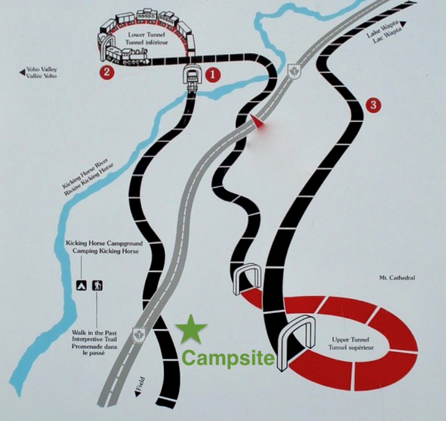

Bill ended the days entry with “I cooked the chili tonight and it was excellent!!!!”
Back toward the U.S. Dust – Phoey! Tuesday, July 14, 1936 – Bill opened with “Mon deux frères birthday! Letter written – OK.” He was celebrating his brother Chuck’s birthday. He continued, “Went to Emerald Lake in the car first this A.M. which is by far the most beautiful of all the aforeseen Canadian lakes with the exception of Moraine.” Since the beauty of glacial lakes is in the eye of the beholder, you be the judge. Moraine is pictured on the left below.


They returned from Emerald Lake, retrieved the trailer, and drove 210 miles back through Castle Mountain, south through Kootenay National Park and Radium Hot Springs, and stopped for the night in Cranbrook BC. Bill described their campground as “…good camp, swimming pool n’ everything!!” Unfortunately, they “Had a new generator installed after we had been shaken to bits by the terrible Canadian roads.” No mention was made of any remarkable sights across their day; however, this map shows the route they drove through the park. In all likelihood, by taking this route, they would have seen from the car windows Vermillion Crossing, Kootenay Crossing, and Sinclair Canyon Pass as pictured in that order below.


What Ho!! – U.S. Dust and more Dust! [With no context, his title might be referring to airborne dust from the endless dust storms in Oklahoma at the time. Not sure how wind-borne dustbowl detritus could travel east to west and south to north. Not the general prevailing wind directions. Historical reports showed dust did reach Mt Shasta in northern California.] Wednesday, July 15, 1936 – Verbatim…”Once more ready to tackle those awful gravel roads, we left Cranbrook at 8 A.M. In an hour or so, we completely shook the daylights out of the trailer and spent two hours in Bonners Ferry, ID having it completely repaired. From there, the roads got better encouraging us a wee bit. We hit Spokane Wash about five o’clock where I got no mail – sniffle, sniffle. After Abie bought out the stores there, we went on about 40 miles to Davenport where our little camp is now pitched. Which reminds me, I got letters to write!!”
Dear Old Washington; Thursday, July 16, 1936 – “We bid adieu to Davenport on the stroke of eight and began our westward trek once more. The general appearance of the land resembled that of South Dakota. We stopped at the Grand Coulee Dam site and thoroughly viewed this monstrosity. Quite something!” The dam would have still been under construction, as it wasn’t completed until 1942. Here was what it looked like in 1936 versus today.


Bill continued “Drove through Ellensburg and Yakima, landing tonight about 300 miles from Davenport in a national forest just a short way from Rainier National Park. Very elegant campsite next to a stream and among giant trees.”
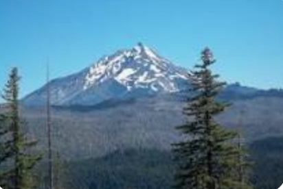
Oh these days of rest!! Friday, July 17, 1936 – “With only a short distance to travel, we reached Rainier quite early in the morning and immediately got ourselves oriented as usual. A short hike in the morning and a long one in the afternoon thoroughly wore me down again. We had great fun sliding down some long snow slides in the mts. – we had more fun trying to dry out our clothes!! Boy the mosquitos are the worst ever – the ‘miserable critters’ as Abie would say.” MFI and I never took the time to hike on Mount Rainier, but it was breathtaking every time we saw it as shown here.


The excellence of Civilization: Saturday, July 18, 1936 – “Again a short trip has gotten us to our destination. We didst [sic] arrive here shortly before noon and before nightfall had seen most if not all of Seattle – thanks to J. Wanamaker.” Seattle in 1936 was a far cry different from what visitors would see today: no space needle, no fisherman’s wharf, no gum wall, and no Starbucks.


“We had a hard time trying to figure out what a ‘bathtub’ was but finally did and used it to a good advantage. Our sleeping quarters consist of a house rented for that purpose and the meals are disgustingly good. Abie lost his beard today – Ha Ha.”
Church again – My, My; Sunday, July 19, 1936 – “What a night – Vittorio [not sure if this was Abie or David] snores like a steam engine and soft beds don’t agree with me! – not right now anyway. Had a gorgeous breakfast on Mrs. Gunnison after which we attended church with Ellie Thomassin & her mother. Ellie, bless her, decided that we might like to see some tennis, – sooo we ate lunch – 3 of us – at the tennis club after which we witnessed the finals of the Wash. St. champ. singles. – Had one elegant time. After supper we were driven about town, to the lighthouse, locks, etc. by one Marshall Dutton – Principia faculty.” Unfortunately, Bill offered no details about the people who graciously hosted them.
My poor, flat feet! Monday, July 20, 1936 – “Arising in a rush we lit out for the Ferry Dock from which we sailed on the ‘Kalakala’ to the Bremerton Navy Yard. John W. [Wannamaker] knew the admiral in charge so we saw very thoroughly the aircraft carrier ‘Ranger,’ among other boats.” The significance of the USS Ranger (CV-4) was that it was the first U.S. vessel designed and built from the keel up as a carrier. She was commissioned from 1934-1946 and served in WW II in the Atlantic Theater.


“We had lunch on the ferry on the return trip & went from the docks to the Boeing Plant.” The significance of this visit was that construction of Boeing Plant 2 had just been completed and begun producing the B-17 Flying Fortress, which played a critically important role in WW II.


“Tonight we had a dinner given in our honor which was very super deluxe. Between the four of us [uncertain who the fourth person was] we gave it the right spirit and had a great time. Tomorrow we leave again.”
Back to Canada; Monday, July 21, 1936 – “This morning we had to give up our super beds at the Wannamaker’s and left for Canada about 10:30 A.M. and arrived in Vancouver at about 3:00. We had about two hours to kill before sailing time so we saw bits of the town.”

“‘The ‘Princess Elaine’ left at 5:45 for [Vancouver Island]…We had a lot of fun for two hours roaming hither and yon on the boat and landed at 8:00 at Nanaimo. It is in this thriving burg that we are pitching camp this fair eve. – and no mosquitos!! Whoops.”
My, my, the wilds again!!; Wednesday, July 22, 1936 – “Hot Dog! – We slept till [sic] 8:00 A.M. This day we journeyed up Vancouver Island to Courtnay and from there went a few miles back into the hills to camp which is in the middle of nowhere. The forest around us has been burned over and is quite rugged and barren. Sooo, we took a trip up Mt Beecher [sic] – about a 1,200 ft climb, to work up an appetite for the evening meal. The weather has been perfect and the roads terrible. Today we have gotten into some man-eating flies and mosquitos.”

On to Victoria; Thursday, July 23, 1936 – “Another night with these man-eating mosquitos and my bones would be picked clean! – Practically no sleep at all as a result! After this sleepless night we drove about 180 miles over bouncy roads to Victoria. This grand old city did a good job of making us feel better. – We drove about 40 miles around town. We saw the gorgeous gardens of Mr. Butchart and the world’s second largest reflector telescope – 72 in. at the Dominion Observatory. We also saw the famed Empress Hotel. In the evening we saw two very lousy movies and then went to a camp that was nothing short of perfect.”

All three of the attractions visited by our travelers were subsequently designated Canadian Historic Places. The Butchart Gardens were actually the vision of Jenny Butchart. The Sunken Garden was completed in 1921 and remains family owned.

Plus current pictures below


They had seen the Plaskett telescope, which achieved first light in May 1918 at the Dominion Astrophysical Conservatory, and it actually had a 73-inch mirror. The mirror had to be ground twice from a 12-inch thick, 4,340 pound piece of glass from Antwerp and took two years. This delay was what caused it to not become the largest reflector telescope (at the time) by a mere seven months.

The Empress Hotel was built by the Canadian Pacific Railroad and opened in Jan 1908. It became the Fairmont Empress in 1999 and was named Canada’s #1 luxury hotel in 2024. It’s little wonder their visit made them “feel better.”


To Portland; Friday, July 24, 1936 – “After a very swell night at Victoria, we left for the ferry in good spirits. But, when the ferry was an hour late we lost the good spirits as we had 260 miles to travel between noon and nightfall. Anyhow, we didst [sic] arrive in Port Angeles at 12:00 and started immediately for Portland where we finally got ourselves to at 7:30. Looks like a nice town. Haven’t as yet heard from Doc Reed whom we have called. Saw the Olympic mt. range today – big allright [sic].”

And then to Crater Lake; Saturday, July 25, 1936 – “Being very systematic and habitual, we left Portland at A.M. [sic] again. About the crowning surprise of the day was the presence of A-1 roads. We made better time today than ever – having gone 300 miles in 8 hours. We saw Mt Hood, Mt Adams, Mt Jefferson & a flock of other high peaks.”

“Also, we got to Crater Lake at 4 where we didst [sic] proceed to do the washing & various & sundry other little details. The chipmunks are very tame here & climb all over you. The lake is a super blue etc…..”

Lo and Behold – Mail!!! Sunday, July 26, 1936 – “Due to a sudden decision to go to church, we all turned out early and got all shaven and cleaned up – such a painfull procedure! With all haste we drove [77 miles] to Medford, OR and carried out our plans. We were greatly disappointed at not finding the Leverettes home – however we did get our mail and had dinner. Shortly after we started, the generator went bad. That was fixed and we spent the night in Dunsmuir about 100 miles south of Medford. It is plenty warm again.”
San Francisco in the offing; Monday, July 27, 1936 – With an unusually late start we drove 362 miles to San Francisco Bay where we are at present camped in a baseball field at Mill Valley thru [sic] the courtesy of the local police force. On the way down we saw Mt Lassen, Shasta.”


“Also orange groves, fig orchards and lots of grapes. We followed the Red-Wood highway but were too far south to see the giant trees. – We will see them in Yosemite however. We also got a view of San Quentin and a flock of old sailing ships in their well known graveyard. It is very foggy and terribly cold!-“
Here are pictures of San Quentin as they saw it in 1936 and how it looks today, still an active prison after 173 years and many upgrades and restorations.


– Voila!! – Tuesday, July 28, 1936 – “Bay trees – phew!! We slept under one with a colony of ants. We took a ferry from Sausalito to San Fran across the Golden Gate. On the way we saw the two new bridges and Alcatraz in full view.”
Again, here are the two bridges (Golden Gate and S.F.-Oakland Bay) still under construction and Alcatraz as they saw them in 1936 as compared to how they look today.


“We left the trailer at a garage and proceeded to see the town. First the whole waterfront – stinking fish and all. Next a complete and detailed trip through China-town, through the army post [The Presido] and finally to Golden Gate Park where we saw the Aquarium, Museum etc: – Also seal rocks. Then the C.S. [Christian Science] Sanitorium.”
Vintage pictures of Fisherman’s Wharf and Chinatown…


The three probably just drove through the main roads of the Presidio, since it covers over 2 square miles. Here are similar aerial shots from before 1936 (hence no Golden Gate Bridge) versus today.


Golden Gate Park is also very large, stretching 3.5 mile west from the center of San Francisco to the Pacific coast. Each of the facilities they visited were subsequently reconfigured or replaced, so here are period photos only of the Steinhart Aquarium and de Young Museum.


Last, they visited Seal Rocks, famous for being a coastal sea lion habitat and site of ship wrecks, and the Christian Science TB Sanatorium which was part of the Christian Science Community known as Arden Wood’s.


“Then headed south. We got as far as San Mateo where we are staying with some of V’s [Vittorrio’s] friends quite by accident.”
Yosemite & no mosquitos!!! Wednesday, July 29, 1936 – “This is the best yet! – We have now finished a night sleeping in a backyard (Mrs. Phillips – 50 Bellevue, San Mateo). Not Bad, what with the dogs, cats, croquet sets and a few loose automobiles! – We got away after a good breakfast and went south to Palo Alto where we saw Leland Stanford and Hoover’s home.”
Leland Stanford (1824-1893) was a successful businessman and politician best known for being one of the “big four,” who were responsible for building the transcontinental railroad. Leland and his wife subsequently established Stanford University in honor of their son who died of typhoid fever before turning 16. The Stanford country house in Palo Alto was one of several he owned. The second home toured was the Lou Henry (Hoover’s wife) and Herbert Hoover House (built 1920), which sits on the Stanford University Campus and serves as quarters for each university President.


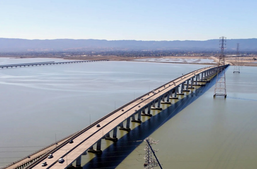
“From there across the Dum Barten [sic] bridge to Hayward, Merced, Fresno and Yosemite.” The Dumbarton was the first vehicular bridge to cross San Francisco Bay in 1927 for $2.25 M. The original was replaced in 1984 for $70 M.

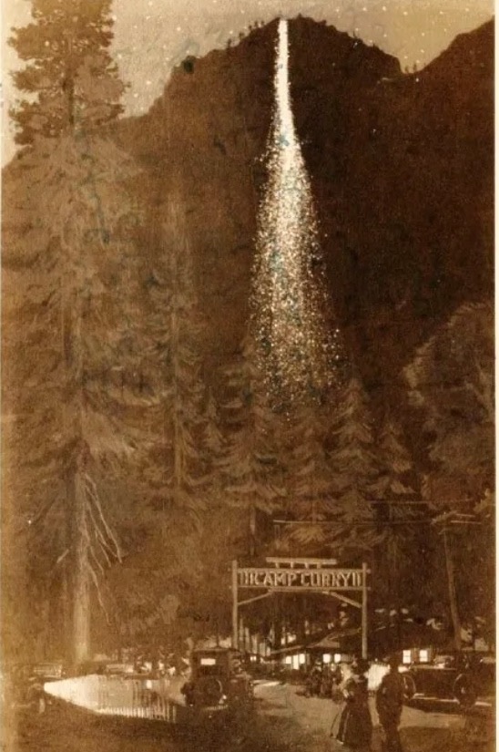
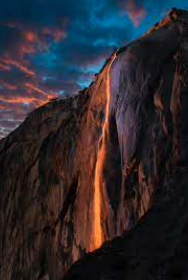
“Today already we have seen the Bridal Veil falls and the evening ‘fire falls.’ I may be goofy, but this is the best yet! Beauty beyond conception – topped off with an almost full moon, perfect weather, super clear night, and no mosquitos!”


What Weather!! The mosquitos grow into bears!! Thursday, July 30, 1936 – “I rather imagine the ants had a good sleep last night even if I didn’t, – they seemed to be enjoying the comforts of my sleeping bag quite extensively!! Also, a playful black bear almost finished off our camp about 1:00 AM this morning. After swatting the icebox across the landscape he headed for Abie’s tent. Abie arose and scared the bear more than the bear scared him – all’s OK. We saw the whole of Yosemite & have journeyed over to Gen Grant Nat’l Park to sleep among the giant sequoias. The temp. has dropped from 116 [degrees] in the valley to almost 55 [degrees] in the mts. The moon’s almost as bright as the sun and I’m tired – g’nite!”
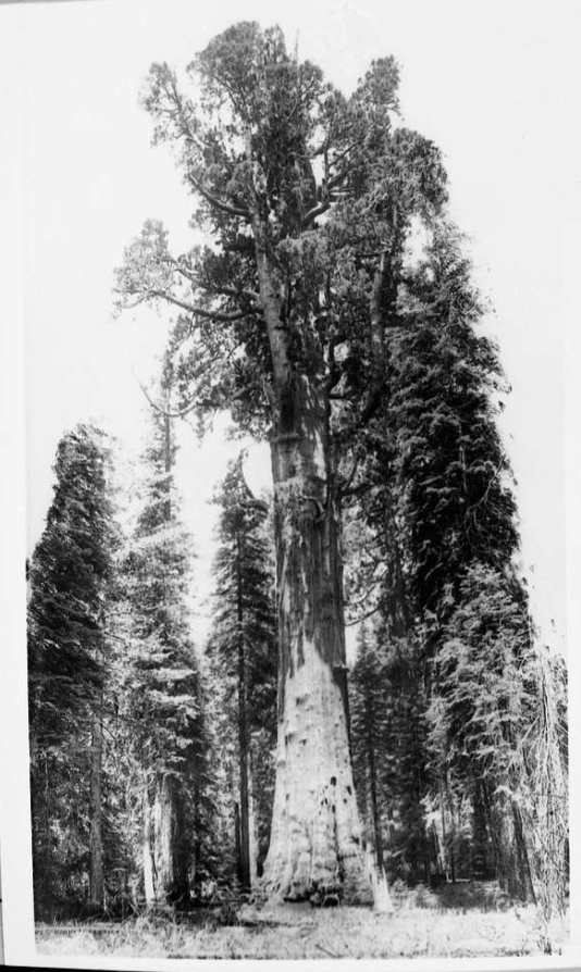
The Last Day; Friday, July 31, 1936 – “At last the time has come – tomorrow we will be at the trips end and be left to roam in the bowels of the city of Los Angeles. This A.M. we saw the Gen. Grant and Sequoia parks in detail – the big trees were of course the main item of attraction, one being over 40 feet in diameter.”
The General Sherman is the biggest sequoia in Sequoia National Park with a trunk diameter of 25 feet and a circumference of 40 feet; therefore, I believe Bill’s description was referring to it. By volume, it is the largest living single-stem tree in the world. Its age is estimated at between 2,200-2,700 years, although it is not the world’s oldest tree. Between 1936 and now, the tree has added an estimated 3,560 cubic feet of wood. This volume is equivalent to 89 trees each 100 feet tall. The General Sherman stands 275 feet tall.
Here are vintage General Sherman trunk and height photos as compared to today.


“We also came down out of the Sierra Nevada Mts. today on the windiest road of the whole trip – almost 40 miles in second gear. We have gotten as far as San Fernando tonight and will be in L.A. at 9 or 10 tomorrow, so Uncle Abraham says! Well, guess I’ll go to bed for the last time under the full moon and stars.”
THE END
EPILOG
By any measure, this road trip was an incredible, once-in-a-lifetime adventure. Bill, David, and Abraham saw more in 40 days than most people witness in a lifetime. We didn’t want the journal to end, and we were left with so many questions about the few details Bill was able to record. Unfortunately, the answers must remain a mystery.
Certainly left to the imagination is how everyone returned home. Commercial air travel was in its infancy. Likely this was not the means. LA’s Union Station was under construction, however there was, as of early 1936, a train running all the way to Chicago. While this would have been possible, what would they have done with the car and trailer? Perhaps they drove their vehicle on Rt 66 all the way to Chicago. Definitely possible.
Also stunning is that this was during the height of the Depression. The three had to have all come from families of stable means to be driving their own vehicle, towing a trailer however small, paying for fuel, vehicle and equipment repairs, food along the way, campsites, and occasionally lodging in hotels clearly in the more expensive range. The Old Faithful Inn would have cost them $20, which is over $450 in today’s money. Today’s rates are upward of $580 for a standard room for 3 adults.
Regardless of all the questions left to our 21st century imaginations, what an adventure. N’est-ce pas?